
Canada’s geography presents a significant logistical challenge for the casual traveler. Spanning 9.98 million square kilometers, the nation is the second-largest in the world by total area, yet its population density is among the lowest, at approximately four people per square kilometer. For those planning a road trip, this translates to vast distances between refueling stations, varied provincial traffic regulations, and significant climatic shifts across a single itinerary. Success in navigating the Canadian landscape depends less on spontaneity and more on a rigorous understanding of regional infrastructure, seasonal windows, and vehicle performance requirements. This report evaluates five primary routes based on technical difficulty, resource availability, and geographical significance.
Trans-Canada Highway Planning: Distance, Timing, and Regional Logistics
The Trans-Canada Highway is not a single road but a network of provincial highways spanning 7,476 kilometers (4,645 miles) from St. John’s, Newfoundland and Labrador, to Victoria, British Columbia. It is one of the world’s longest national routes. For travelers attempting a full crossing, the logistics are formidable. A standard transit requires a minimum of 10 to 14 days of sustained driving, assuming an average of eight hours behind the wheel daily. However, such a pace precludes any meaningful engagement with the landscape. A more realistic timeframe for a cross-country expedition is 21 to 30 days.
Segmented Distance and Fuel Considerations
The route is divided into distinct geographical zones, each with unique requirements. The Atlantic segment involves ferry crossings managed by Marine Atlantic; the 16-hour transit from North Sydney, NS, to Argentia, NL, costs approximately $500 CAD for a standard passenger vehicle and two adults. Once on the mainland, the transit through Northern Ontario is often cited as the most difficult logistical phase. The stretch between Sault Ste. Marie and Thunder Bay covers nearly 700 kilometers of the Canadian Shield, where fuel stations are infrequent and cellular service is intermittent. Drivers should maintain a half-tank minimum policy in this region. The Prairies (Manitoba and Saskatchewan) offer high-speed, flat transit but are prone to extreme crosswinds that can impact the fuel efficiency of high-profile vehicles like SUVs or campervans by as much as 20%.
Infrastructure and Speed Regulations
Speed limits vary by province. In British Columbia and Alberta, limits on divided highways often reach 110 km/h or 120 km/h. Conversely, in Ontario, the maximum is generally 100 km/h, though recent pilot programs have increased sections of the 400-series highways to 110 km/h. Enforcement is strict, particularly in construction zones where fines double. Travelers must also account for the “Move Over” laws prevalent in all provinces, which require drivers to slow down and move to the far lane when passing emergency vehicles or tow trucks with flashing lights.
The Icefields Parkway: Navigating Jasper and Banff National Parks
Stretching 232 kilometers (144 miles) between Lake Louise and Jasper, Highway 93 North—commonly known as the Icefields Parkway—is widely considered the most aesthetically significant drive in North America. From a technical standpoint, the route is a high-elevation mountain passage reaching 2,068 meters (6,785 feet) at Bow Pass. This elevation introduces specific mechanical and safety considerations, even during the peak summer months of July and August.
Seasonal Access and Vehicle Requirements
The Parkway is subject to strict winter tire mandates from October 1 to May 31. Vehicles must be equipped with tires bearing the mountain/snowflake symbol or M+S (Mud and Snow) rating with a minimum tread depth of 3.5mm. Failure to comply can result in significant fines and, more importantly, loss of traction on the steep grades of the Big Bend or Sunwapta Pass. There is only one refueling station on the entire 232km stretch—Saskatchewan River Crossing—which typically charges a 25-30% premium over fuel prices in Banff or Jasper. It is standard practice to fill the tank before exiting the town sites at either end.
National Park Entry and Capacity Management
Entry to the Icefields Parkway requires a Parks Canada Discovery Pass. For 2024, a daily pass for an adult is $11.00 CAD, while a family/group pass is $22.00 CAD. For trips longer than seven days, the annual Discovery Pass ($75.25 for individuals, $151.25 for families) is the more cost-effective option. Parking at major sites like the Columbia Icefield Discovery Centre or Peyto Lake is frequently at capacity by 10:00 AM. Data from Parks Canada suggests that peak visitation occurs between 11:00 AM and 3:00 PM; logistical efficiency is maximized by starting transit at sunrise.
The Cabot Trail: Coastal Geography and Cape Breton Driving Requirements
The Cabot Trail is a 298-kilometer (185-mile) loop around the northern tip of Cape Breton Island in Nova Scotia. The route is characterized by its dramatic transition from sea-level coastal roads to high-plateau barrens within the Cape Breton Highlands National Park. The topography involves grades of up to 13%, which places significant strain on vehicle braking systems and cooling units.
Technical Driving and Engine Braking
Drivers navigating the Cabot Trail in a clockwise direction (starting in Baddeck and heading toward Margaree) will find themselves on the “inside” lane during the steep climbs. Moving counter-clockwise puts the vehicle on the “outside” lane, providing more direct views of the Gulf of St. Lawrence but requiring more focus due to the proximity of steep drop-offs. Professional drivers recommend utilizing engine braking (downshifting) when descending North Mountain or Mackenzie Mountain to prevent brake fade. This is particularly relevant for those operating heavier rental RVs, which are common on this route.
Wildlife and Visibility Hazards
The Cape Breton Highlands have a high density of moose (Alces alces). These animals can weigh up to 600kg and are most active at dawn and dusk. Collisions are frequently fatal for both the animal and vehicle occupants. Statistics from Nova Scotia’s Department of Public Works indicate that the majority of wildlife-related accidents on the Cabot Trail occur during low-light conditions. Consequently, night driving is strongly discouraged for visitors unfamiliar with the terrain. Fog is another significant variable; coastal advection fog can reduce visibility to less than 50 meters within minutes, particularly in the Chéticamp area.
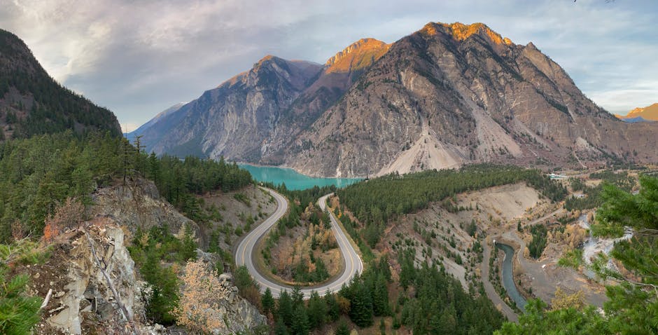
The Sea-to-Sky Highway: Technical Driving and Seasonal Constraints
Highway 99, connecting Vancouver to Whistler and continuing to Pemberton and Lillooet, is a masterclass in civil engineering. Following the 2010 Winter Olympics, the road underwent a $600 million CAD upgrade to improve safety and capacity. Despite these improvements, the route remains a challenging drive due to its rapid elevation gain and high traffic volume. The 120-kilometer stretch from Vancouver to Whistler transitions from sea level to 670 meters, often involving heavy rainfall that turns to snow as the elevation increases.
Winter Tire Regulations and Enforcement
Like the Icefields Parkway, the Sea-to-Sky Highway has a legal requirement for winter tires from October 1 to March 31. This is strictly enforced by the Royal Canadian Mounted Police (RCMP) at checkpoints. For travelers renting vehicles in Vancouver, it is imperative to verify that the rental agency has provided a vehicle with the appropriate “M+S” or “3-Peak Mountain Snowflake” rating. Many standard rental fleets in the city are equipped with summer or all-season tires that do not meet the legal threshold for Highway 99 during the winter months.
Traffic Flow and Weekend Congestion
Data from the BC Ministry of Transportation shows a significant spike in traffic on Friday afternoons (northbound) and Sunday afternoons (southbound). During peak ski season or summer weekends, the transit time between Vancouver and Whistler can double from 90 minutes to three hours. Travelers are advised to monitor the “DriveBC” portal for real-time updates on accidents and construction. The section between Horseshoe Bay and Squamish is particularly prone to closures because the geography allows for few detour options; a single accident can halt traffic for several hours.
The Gaspé Peninsula Loop: Maritime Navigation and Quebec Route 132
The Gaspésie region of Quebec offers a road trip experience centered on the St. Lawrence River estuary. The primary route is a loop of Highway 132, covering approximately 885 kilometers (550 miles) starting and ending in Sainte-Flavie. This route is unique for its cultural immersion and the specific challenges of navigating rural Quebec, where French is the primary language for all road signage and services.
Directional Strategy and Coastal Erosion
The standard recommendation for the Gaspé loop is to drive in a clockwise direction. This keeps the vehicle on the right side of the road, closest to the water, providing unobstructed views of the Percé Rock and the Gulf of St. Lawrence. However, Highway 132 is increasingly affected by coastal erosion and storm surges. In recent years, sections of the road near La Martre and Marsoui have required emergency repairs due to wave action. Travelers should check Quebec’s “Quebec 511” service for active roadwork alerts, which are frequent during the summer maintenance season.
Regional Services and Language Logistics
While major tourist hubs like Percé and Gaspé have English-speaking service staff, smaller villages along the northern coast (the Haute-Gaspésie) may not. It is practical to have a basic understanding of French road signs. For example, “Arrêt” (Stop), “Cédez” (Yield), and “Travaux” (Roadwork) are essential terms. Furthermore, the availability of high-speed EV charging stations (Circuit Électrique) is surprisingly robust in Quebec compared to other provinces, making the Gaspé Peninsula one of the most viable long-distance routes for electric vehicle owners in Canada.
Comparing Vehicle Rental Costs and Fuel Efficiency for Canadian Travel
The choice of vehicle is the most significant variable in the total cost of a Canadian road trip. The vast distances ensure that fuel consumption will be a primary expense. In 2024, fuel prices in Canada have fluctuated between $1.50 and $1.85 CAD per liter for 87-octane gasoline, with prices significantly higher in British Columbia and the Atlantic provinces than in Alberta.
| Vehicle Category | Estimated Daily Rental (CAD) | Avg. Fuel Economy (L/100km) | Pros | Cons |
|---|---|---|---|---|
| Compact/Intermediate Sedan (e.g., Toyota Corolla) | $65 – $95 | 6.5 – 7.5 | Highest fuel efficiency; easiest to park in cities. | Limited storage; poor performance on unpaved access roads. |
| Intermediate SUV (e.g., Toyota RAV4) | $85 – $130 | 8.0 – 9.5 | AWD capability; better visibility; comfortable for long hauls. | Higher fuel cost; higher rental premium. |
| Small Campervan (e.g., Ford Transit Conversion) | $200 – $350 | 12.0 – 15.0 | Eliminates hotel costs; allows for cooking on the road. | Expensive fuel; difficult to navigate in tight mountain passes. |
| Full-Size Pickup (e.g., Ford F-150) | $110 – $160 | 11.0 – 13.5 | Highest ground clearance; essential for remote gravel roads. | High fuel consumption; excessive size for urban areas. |
Insurance and Liability Considerations
When renting a vehicle in Canada, the Collision Damage Waiver (CDW) or Loss Damage Waiver (LDW) can add $25 to $40 per day to the base rate. Many premium credit cards provide secondary or even primary rental insurance coverage, but it is critical to verify that the card’s policy covers the specific vehicle type (many exclude campervans or luxury SUVs) and the duration of the trip (often capped at 21 or 28 days). For international visitors, a valid driver’s license from their home country is typically sufficient, though an International Driving Permit (IDP) is recommended if the original license is not in English or French.
Expert Note: Alberta consistently maintains the lowest fuel prices in Canada due to lower provincial fuel taxes. When planning a route through the Rockies, it is financially advantageous to refuel in Calgary or Canmore before crossing the provincial border into British Columbia, where prices can be $0.20 to $0.40 higher per liter.
The logistical success of a Canadian road trip is predicated on acknowledging the country’s scale. Attempting to cover too much distance in a single day is the primary cause of traveler fatigue and safety incidents. By selecting a route that aligns with the vehicle’s capabilities and the driver’s experience level, and by accounting for the technical requirements of the terrain, travelers can effectively manage the complexities of the Canadian landscape.